
Ⅰ. Utilize GPS and Flight Logs
Almost all modern drones record GPS data and flight paths during flight, which are crucial for retrieval.
Open the drone's official app to view the last known GPS coordinates and flight path;
Use third-party services to export more detailed flight logs, sometimes accurately showing the location before disconnection;
Use the "Find Drone" function to directly locate the drone on a map or generate a location QR code, which can be used in conjunction with navigation software.
The last coordinates in the flight log are the starting point for the on-site search.
Ⅱ. Real-world Case Study: Successfully Retrieving a Drone Using GPS Data
A team lost control of their drone and crashed into water, disappearing without a trace. However, they had previously obtained GPS location information from the flight logs and analyzed it as a search point. Ultimately, they used auxiliary equipment to retrieve the vehicle from near the water's edge.
This example clearly illustrates that the first step should be analyzing the point of loss from the flight logs, rather than blindly searching everywhere.
III. Core Strategies for Preventing Drone Loss
1. Thoroughly Check Equipment Before Flight
Specifically check the following:
The drone body has no obvious damage;
The battery connection is secure, with no leaks or bulges;
The remote controller and flight controller firmware are up-to-date;
GPS and compass sensors are calibrated.
These simple checks can significantly reduce unexpected problems during flight.
2. Practice and Familiarize Yourself with Aircraft Functions
Many novice drone pilots are not familiar with the aircraft's loss-of-control response procedures, such as the execution mode after signal loss. If you are familiar with settings such as (return-to-home) and priority behaviors beforehand, you can take action more quickly when communication is lost.
For example, before flying in complex terrain or areas with strong interference, pay attention to:
Whether the GPS signal is stable;
Whether there are obstacles obstructing the view;
Whether the battery level is sufficient to support return-to-home.
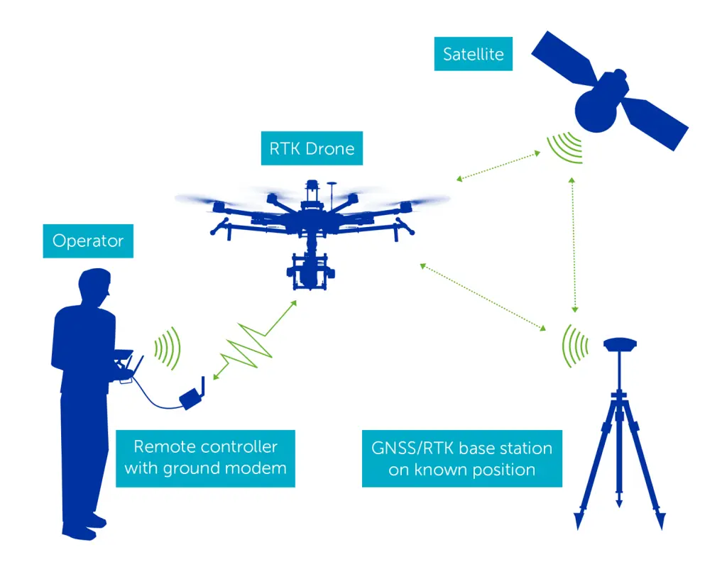
3. Ensure a Good GPS Signal
GPS signals are greatly affected by the environment. Before takeoff, ensure the following:
Wait sufficient time in an open area for GPS signal acquisition;
Avoid flying in areas with tall buildings or dense trees;
Check the GPS bar count displayed on the flight controller before flight to ensure it is sufficient.
When the GPS signal is weak, the drone's positioning, return-to-home, and search functions will be severely affected.
IV. Positioning When the Battery is Low
1. Setting up Smart Return-to-Home
Most consumer drones support automatic return-to-home (Return to Home) when the battery level is low. When enabled, the drone will automatically return to your takeoff point when the battery level drops to a preset threshold.
Ensure that the battery threshold is set according to the flight environment, not the default value, so that the drone has enough power to return.
2. Battery Maintenance Habits Are Equally Important
The battery is the core component for drone operation. Daily maintenance requires attention to:
Checking the battery health status regularly;
Testing the voltage difference before and after use;
Avoiding storing the battery for extended periods when it is too low or too high.
Proper battery maintenance can extend flight time and prevent sudden power outages during flight.

3. Attach Contact Information to the Drone
While not a technical solution, attaching your name, phone number, and other contact information to a clearly visible location on the drone is an effective way to retrieve it. If someone finds your drone, they can contact you to return it.
V. Search Options Without GPS
If the drone is lost without GPS or with unstable GPS tracking, more traditional but effective search methods must be employed.
1. Manual Ground Search
Starting from the last known direction, search the surrounding area in a grid pattern. Drones often land in easily obscured areas such as bushes or grass, so careful observation is necessary.
2. Aerial Search with an Assist Drone
If you have a second drone, use it to hover at low speed and search the target area. A bird's-eye view makes it easier to spot drone wreckage or the drone itself.
3. Utilize Community Resources
Post on online communities, flight forums, or local aerial photography groups, asking for help in locating the lost drone. Collective efforts are often more effective than individual searches.
4. High-Frequency Signal Positioning Technology (Advanced Method)
For drones lacking GPS, radio direction finding techniques or drone inertial measurement unit (IMU) data analysis can be used to infer the last known trajectory. These methods require specific equipment and expertise and are generally used by experienced teams conducting searches.
VI. Summary and Practical Recommendations
Losing a drone is a major headache, but with a systematic approach, the chances of recovery can be significantly increased:
Check GPS and flight logs immediately to pinpoint the last known location;
Perform equipment checks and set return-to-home parameters before flight;
Battery maintenance and attaching contact information can help locate the drone after a power outage;
When GPS is unavailable, employ manual ground/air search and community collaborative search strategies.
By using these strategies, you can not only improve the success rate of recovering your drone but also effectively avoid similar problems in future flights.
